|
The
Geology of Salt Point State Park
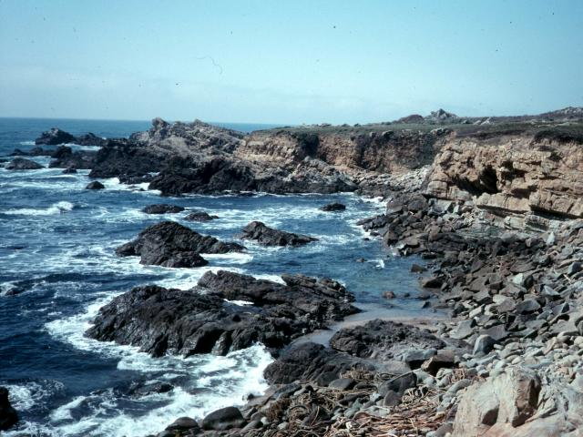
Salt Point State Park provides
the visitor spectacular vistas of the ocean, with rugged
offshore rocks and steep sea cliffs that take the full impact of
the waves. The rocks are sculpted into an infinite variety of
forms and shapes. Extending underwater, the rocks offer a range
of habitats to a wide variety of marine plants and animals.
Divers can enjoy the rich underwater world.Uphill from the
coast, the park continues to the top of the coastal ridge.
Habitats change from coastal grassland to forests of Bishop
pine, madrone, tanoak, and redwoods. There is also a pygmy
forest of stunted cypress, pine and even redwoods, and a large
open "prairie".
What
makes Salt Point State Park so special? What has created this
unique and unusual landscape? There are many more questions than
an we can easily answer, but we can begin to unravel the
mysteries of the park's origin and formation. We can look
beneath the surface at the dramatic geologic processes that
create this magnificent landscape. The terrain of the park has
been formed and modified over tens of millions of years. The
processes involved in its formation include those processes that
move continents and create oceans, build mountains and generate
destructive earthquakes.
To fully appreciate the geologic
history of the Salt Point State Park, it is helpful to
understand how the rocks of the park formed and the dynamic
processes involved in the creation of the coastal mountains of
California.
ROCKS AT SALT POINT
There are three types of rocks:
igneous, sedimentary, and metamorphic
defined on how they are formed. Igneous rocks were molten
at some time in their history. The melt is called magma
when it's found beneath the earth's surface or lava when
it is erupted onto the surface. When the melt cools, it forms a
rock made of intergrown, interlocking crystals composed of
several different minerals. When the melt cools slowly, the
crystals have time to grow large producing an igneous rock such
as granite. If the melt cools quickly, the crystals that form
are very small, often too small to be seen with the unaided eye.
Basalt is an example of a lava that cooled quickly.
Sedimentary rocks
are formed on the earth's surface by surface processes, such as
weathering, erosion, deposition, and cememtation. When any type
of rock (igneous, metamorphic, or sedimentary) is exposed at the
earth's surface, it comes in contact with the atmosphere which
is very corrosive. The rocks are mechanically broken apart and
react chemically with oxygen in the atmosphere and weak acids in
rain water . These weathering processes breaks the rock into
smaller particles that are then transported by wind, running
water, ocean currents, or glaciers; they are eroded. Eventually
the rock particles are deposited in some low place, such as on
the bottom of a lake or on the floor of the ocean, and they
accumulate layer by layer. The weight of the overlying sediment
and the precipitation of minerals in between the rock particles
turns the loose sediment into solid sedimentary rock.
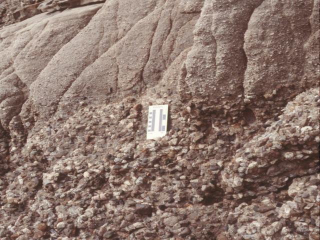
Sedimentary rocks are classified
based on the size of the particles making up the rock. Large
rounded pebbles cemented together form a conglomerate.
Sand-sized particles form a sandstone, while mud and
clay-sized particles form mudstone and shale. Each of
these types of sedimentary rocks can be seen at Salt Point State
Park, and will be described in greater detail later in this
guide.
If sedimentary rock or
crystallized igneous rock is deeply buried and subjected to high
temperatures and pressures, it will be altered to a new rock
called metamorphic rock. Metamorphic rocks are often made
of crystals, like igneous rock, but the crystals are arranged in
layers (called foliation), reflecting the modifying heat
and pressure. Examples of metamorphic rocks are quartzite,
marble, slate, schist and gneiss.
All of the rocks along the
coastline in the park are sedimentary sandstones,
conglomerates and mudstones. The only metamorphic and
igneous rocks are found in the large, rounded pebbles in the
conglomerates. Granite pebbles are made of white and black
crystals. Volcanic pebbles are usually dark with a scattering of
tiny light-colored crystals. All-white pebbles are usually white
quartz (or quartzite). These types are fairly abundant. Pebbles
made of metamorphic rock are often dark in color and may show
alternating dark and light layers of small crystals. Identifying
these different rock types may be especially difficult when the
pebble has been rounded and polished, and the sample is small.
Even experts may have difficulty so don't get discouraged.
READING THE STORY IN THE ROCKS
Rocks contain a record of their
geologic history: how, when, and where they formed. Geologists
are able to read the story contained within the rocks and they
can interpret and recreate the history of the California coast
through geologic time. It doesn't take a professional to do
this. With a little backround, you can begin to look beneath the
surface and take a voyage back through time.
The story begins over a hundred
million years ago, and involves the formation and movement of
large blocks of crust, called
plates. The outer portion of the earth is divided into
about a dozen rigid plates that are "floating" on a plastic-like
portion of the upper mantle (the layer of the earth beneath the
crust). These plates are in motion; some move apart and some
move toward each other. Where plates move apart, molten magma
comes to the surface in the rift and cools to form new
oceanic crust. When this process occurs under the ocean, the
process is called sea-floor spreading. As spreading
occurs and new crust is formed, the plates move away from each
other. As the plates separate, they move toward other plates.
Where plates collide, one plate moves down under the other, a
process called subduction.
Collision and subduction of
plates are the processes that created most of the rocks of
California. Millions of years ago, the Pacific Ocean plate moved
eastward away from a spreading ridge and collided with the North
American plate. As the two plates collided, North America acted
like a gigantic snowplow and scraped off a thin portion of the
Pacific plate as it was being consumed. Over millions of years,
these "sea-floor scrapings" piled up at the margin of the North
American plate, and today make up much of the rock of the
northern coastal mountains.
For hundreds of millions of year,
the West Coast of North America has been a collision-type plate
margin. There has been a sea-floor spreading ridge to the west,
generating the Pacific Ocean plates. The oceanic plate, formed
at the spreading ridge, moved toward the western margin of the
North American plate, collided with it and was subducted beneath
the North American plate. In the process the rocks of the Coast
Ranges were "scraped off" the descending plate and uplifted.
Farther east, molten rock, generated by the friction developed
as the two plates collided, rose to form granite of the ancient
Sierra Nevada mountains.
THE SAN ANDREAS FAULT
About 25 million years ago, the
California coastline went through a dramatic change. A new type
of
plate margin formed. Instead of colliding, the Pacific and
North American plates moved past each other along a fault: the
San Andreas fault. The cause of this change was the North
American Plate overtaking and overriding the eastern portion of
the Pacific plate and the spreading ridge. The San Andreas
fault, the boundary between these two huge plates, traverses the
State of California from the head of the Gulf of California in
the south to Point Arena in the north. The San Andreas fault
crosses through the eastern part of Salt Point State Park. This
segment of the fault ruptured in the great San Francisco
earthquake in 1906.
The rocks of Salt Point State
Park on the west of the San Andreas fault are very different in
composition and age from the rocks on the east side. The reason
for these differences are because the Park straddles the San
Andreas fault. All of the California continental crust to the
west of the San Andreas fault is attached to the Pacific oceanic
plate and is moving northwest with the Pacific plate. That
portion of Salt Point State Park situated west of the San
Andreas fault is part of this sliver of continental crust called
the Salinian block. These rocks in the park were formed
about 40 - 60 million years ago in a marine basin on the
Salinian block. The basin in which the rocks were deposited was
then situated 200-260 or more miles to the south of where Salt
Point State Park is located today. These rocks have been moved
that distance along the San Andreas fault in the last 20 million
years!
The rocks in the park to the east
of the San Andreas fault are very different in composition and
age. They are called Franciscan rocks (the name applied
to a group of rocks making up much of the Coast Ranges) and are
made of the deep-ocean sediments and portions of oceanic crust
scraped off the descending Pacific Plate as it was subducted
about 100-150 million years ago. Franciscan rocks are difficult
to see in the park because the portion of the park east of the
San Andreas fault is heavily covered with forest and soil, and
Franciscan rocks are just poorly exposed. However, excellent
examples of Franciscan rocks can be seen along the coast south
of the park between Fort Ross and Bodega Bay. As a result of the
mountain building processes that have raised portions of the
California coast, and the movement along the San Andreas fault,
the rocks of Salt Point State Park have been folded and, in some
places, faulted. These folds and faults can be seen in the rocks
along the coast.
ROCKS ALONG THE COAST AT SALT
POINT STATE PARK
The rocks along the beautifully
rugged coastline are tilted sedimentary rocks, mostly sandstones
with interbeds of conglomerates and mudstones, part of the
German Rancho Formation. A formation is a group of rocks
having a similar composition. They are named for a local
geographic landmark. Rancho German, in 1846, was a large land
grant that extended north from Fort Ross. Rocks of the German
Rancho Formation can be found exposed from Fort Ross to Point
Arena. North of Fort Ross, the sequence is thought to be as much
as 18,000 feet thick!
The
sedimentary rocks of the German Rancho Formation were formed
40-60 million years ago during the Paleocene to Eocene Series of
the geologic time scale. These rocks were originally deposited
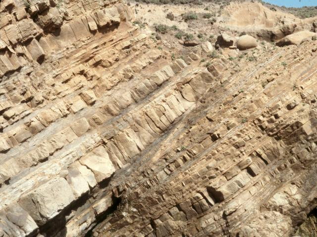
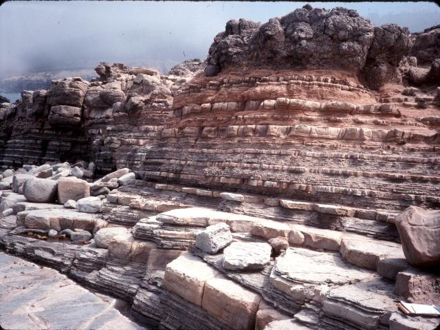
in horizontal layers, like the layers of a cake. Along the
entire coastline of Salt Point State Park, the layers are now
tilted or tipped. This tilting exposes rocks of different ages.
In a sequence of sedimentary rocks, the strata at the bottom is
the oldest (first deposited) and the strata at the top is the
youngest (last deposited). If the sequence of strata remains
horizontal and flat, the only way to see what is below the
surface is to cut a slice into it, as has occurred where the
Colorado River has cut the Grand Canyon through a mile of rock,
exposing older and older rock as you descend to the bottom of
the gorge. On the other hand, when rock is tilted, and erosion
carves the edges, older and older rock is exposed at the
surface. At Salt Point State Park, the oldest rocks are at the
southern boundary and they get younger as you progress northward
up the coast. About a third of a mile south of Horseshoe Point
the rocks are tilted in the opposite direction and get
progressivley older to the north. This is because the rocks are
folded into a downfold called the Horseshoe Point
syncline. The youngest rocks are at the center of a
syncline, and they get older away from the center.
The tilting not only exposes
rocks of different ages, it exposes rocks of different hardness
and resistance to weathering and erosion. The waves wear away
the weaker rock layers from the harder ones, forming coves among
the more resistant points and headlands.
40 - 60 million years ago, when
the rocks of the German Rancho Formation formed , sediments worn
from the surrounding mountains were carried by rivers down to
the ocean. The mud, sand, and pebbles were transported out onto
the floor of a deep submarine basin that was located far to the
south of where Salt Point is located today. The composition of
the pebbles is used by geologists to reconstruct the geography
and environment at the time these rocks were forming.
TURBIDITY CURRENTS AND
DEEP-SEA FANS
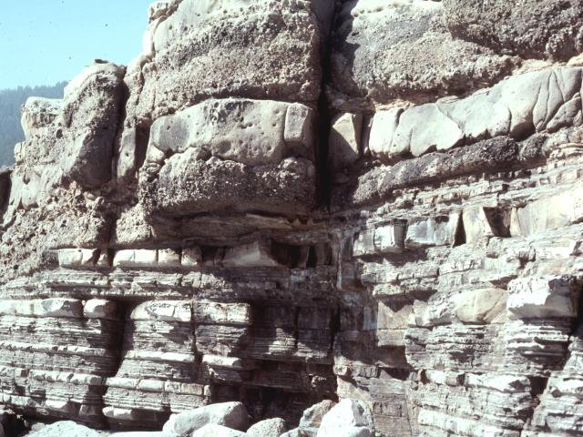
The
thick layers of sandstone alternating with layers of
conglomerate and mudstone in a particular succession, forms a
pattern that is interpreted to have been deposited by flows of
dense, turbulent sediment-laden water flowing down a submarine
canyon. These high density flows are called turbidity
currents. Rapid sedimentation on slopes of the basin may
result in instability. Intense storm activity or an earthquake
may trigger a submarine slide that starts the turbidity current
moving. The flow moves downslope, down the submarine canyon and
then out onto the ocean floor where the sediment is deposited on
a deep-sea fan .
A modern example of these
processes and deposits can be found at Monterey Bay. Today,
rocks in the high Sierra Nevada mountain range are weathered and
the sediment is carried by streams and rivers into the
Sacramento and San Joaquin Rivers, through the Delta, to San
Francisco Bay and out the Golden Gate to the ocean. There
longshore currents driven by prevailing winds, carry the
sediments southward along the coast forming the beaches from San
Francisco to Monterey. In Monterey Bay, the sediments are
funnelled off down the Monterey submarine canyon where they flow
in underwater channels and finally come to rest on the Monterey
deep-sea fan. The fan has numerous channels at the top which
carry the coarsest sediment, such as conglomerates. The sediment
gets finer farther down the fan and in between the channels
where the sediment may have overflowed the banks of the
channels.
The
sandstones and conglomerates at Salt Point are thought to have
formed in the channels, and the thinner beds of sandstone and
mudstones are thought to have formed in between the channels on
a large submarine deep-sea fan millions of years ago. These
channel and interchannel deposits can be seen in many places
along the sea cliffs.
How did these sedimentary rocks
from a deep-sea fan,deposited thousands of feet beneath the
ocean, get raised to their present position above sea level? The
processes that created the coast range mountains can be seen in
action today. On October 17th 1989, a 7.1 magnitude earthquake
rocked the San Francisco Bay region. The epicenter was in the
Santa Cruz mountains. The San Andreas fault ruptured along 25
miles, at a depth of between 11 and 3 miles beneath the surface.
The fault did not break the surface as it did in 1906. After the
earthquake, surveys of the surrounding peaks indicated that the
Santa Cruz mountains had moved about 6 feet upward and 4 feet to
the north. There is evidence at Salt Point State Park of similar
kinds of uplift and northward migration.
MARINE TERRACES
As
you hike or drive along the coast, you will notice broad, flat
surfaces above sea level. These are called marine terraces,
part of the old, uplifted ocean floor. If the water were
suddenly drained from the ocean, you would find a gently sloping
surface running from the beach, offshore to the west. Imagine
what would happen if the land were suddenly raised 20 feet. You
would have a surface like the one you drive across to reach the
coast. In fact, the rocks that rise above the terrace level are
ancient sea stacks, similar to the resistant rocks off
the coast today that take the initial impact of the waves before
they reach the seacliff.
WATER, WIND, AND SALT
The
sandstone seacliffs look as if a sculptor shaped and carved the
rocks into all manner of imaginative forms. In fact, the
sculptor is the wind, waves, and sea spray. Look beyond their
amazing shapes and forms, into their origin and history. If you
look carefully at the sandstones along the coast, you can see
the layering in the sandstone and also see that the layers are
tilted at an angle, exposing their layers to the elements. Some
of the sandstones are harder because they are better cemented
than adjacent sandstone layers. Layers that contain more clay
may be softer. The waves and wind are able to etch and remove
the softer exposed layers, leaving the harder layers standing as
ridges and ribs. The massive sandstones and conglomerates form
the points and headlands; the coves form where the rocks contain
more mudstones or the rock has been fractured.
Another important factor in how
easily rocks are eroded is how broken they are. A fault is a
break along which movement occurs; a fracture or joint is just a
crack in the rock. The close proximity of the San Andreas fault
and the tilting of the rocks indicates that the rocks have been
subjected to stress. In some cases the rocks respond by simply
cracking, in other cases the rocks on the two sides of the break
move, one side relative to the other. As you walk along the
headlands, notice that the massive sandstones are highly
fractured. Differences in color of the rocks due to weathering
often eccentuates the fractures.
Faults also break up the rock.
The fault plane where rocks have been broken can be recognized
by polished surfaces called slickensides. These can be
seen along the road down to Gerstle Cove. Another way to
recognize faults is to see the strata on one side of the fault
displaced from the strata on the other side, or the rocks may be
entirely different in composition or be tilted at a different
angle from rocks across the fault. These features are well
displayed at Gerstle Cove and in the cove to the north of Salt
Point. Gerstle Cove is a cove because the shattered rocks in the
fault zone have been more easily removed by the waves.
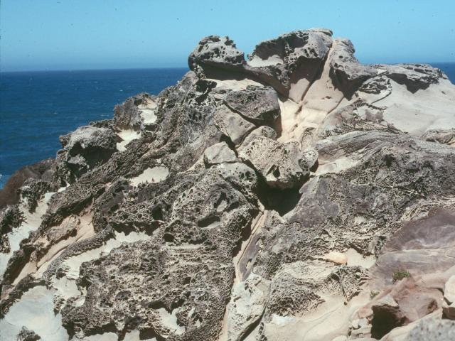
WEATHERING
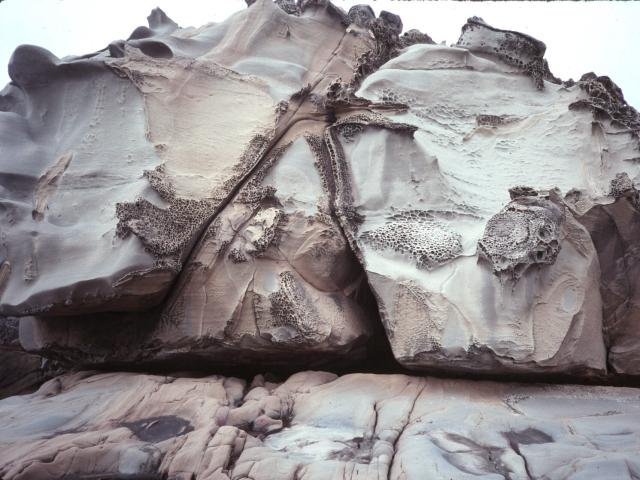
One
of the most unusual and beautiful features of the sandstones
along the seacliffs is the development of a honeycomb-like
network called tafoni.
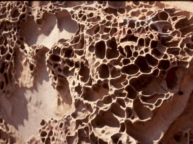
The
exact process of formation of tafoni is not entirely understood.
The waves and salt spray leaves salt crystals on the sandstones.
Salt and water interacting with the cement between the sand
grains, and in minute fractures in the rock alternately hardens
portions and loosens others, creating the lacy, box-like
pattern.
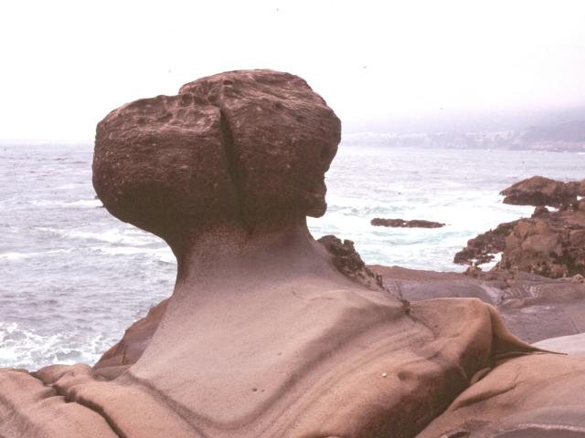
On
some of the points of rock along the coast are large rounded
rocks, some are even standing on pedestals. These rounded rocks
are called concretions. The concretions represent areas
within the sandstone layers where the sandstone is better
cemented than in the surrounding sandstone, and therefore is
more resistant to weathering and erosion.
WAVE EROSION
One of the most awesome sights is
to see winter storm waves battering the coast. Waves strike the
rocks with tremendous force. Water is massive stuff; a cubic
yard of water weighs about a ton! Seismographs used to detect
earthquakes can actually register the minute tremors caused by
the sudden impact of tons of water striking solid rock at the
coast. Storm waves are even more destructive than the force of
the water alone, because waves pick up and hurl sand and
boulders against the shoreline. As the waves break, water
pressure forces sea water into every tiny crack enhancing
chemical weathering of the rock as the water evaporates.
Much of the wave energy is
focused on the headlands which project out into the ocean. The
waves are bent (refracted) around the headland so the force of
the wave is directed against the sides of the headland as well
as at the point. This leads to erosion along the sides leading
to the formation of sea arches. If the erosion isolates
the point of a headland, sea stacks form.
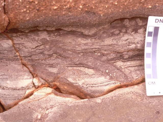
TRACE FOSSILS
Fossils
are traces or remains of once living organisms now preserved in
rock. At Salt Point State Park, fossils can be found in the
sandstones and mudstones exposed in the sea cliffs. These are
trace fossils or ichnofossils (ichno = footprint or track),
which are the tracks, trails, burrows, or borings made by
organisms in the sediment in which they lived. Unlike body
fossils (such as shells or bone), which are the actual hard-part
remains of the organism, trace fossils are indications of the
organisms behavioral activity such as feeding traces, locomotion
tracks, or of its home-dwelling burrow.
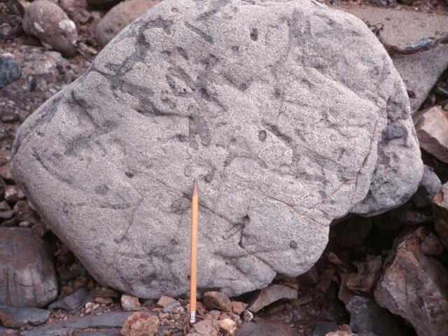
Trace
fossils may not be obvious at first glance. They appear as a
series of straight, curved or branched tubes, about 1/4 inch to
an inch in diameter, within the sedimentary layers. In
cross-section they appear as small circles. Traces are produced
by a variety of animals such as crabs, clams, and worms. It is
not always possible to identify the organism that produced the
track, trail or burrow. However, it has been determined that
certain associations of trace fossils characterize particular
depositional environments. In other words, there is an
assemblage of traces representing shallow water, near-shore
environments, and different assemblages in progressively deeper
offshore waters. The Salt Point trace fossils represent a
deep-water association.
GEOLOGIC PROCESSES AT SALT
POINT STATE PARK
Salt Point State Park provides
the visitor an opportunity to view geologic processes in
operation today and to take a trip through time and space, to
explore the millions of years of earth history recorded in the
rocks, to see the evidence of great plates colliding and
passing, and to see rocks that formed deep on the ocean floors,
composed of materials eroded from mountains long sinced
vanished. A geologic field guide to the coast between Gerstle
Cove and Stump Beach is available for purchase at the Visitor's
Center at the park.
Written and illustrated by Dr.
Sue E. Hirschfeld, Emerita Professor of Geology, Department of
Geological Sciences, California State University, Hayward,
February, 2001. |